Serra do Rio do Rastro: The Cycling Climb Nobody Knows
1,500 metres through 284 curves cut into a cliff face. Serra do Rio do Rastro in Brazil rivals Stelvio, and nobody outside the country has heard of it.
By ZealZag Team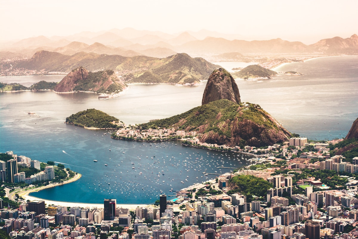
There is a road in southern Brazil that climbs 1,500 metres from subtropical lowlands to a highland plateau through 284 numbered curves carved into a cliff face. The road clings to sheer rock walls with drops of hundreds of metres on both sides. On clear days, the view from the top extends 100 kilometres to the coast. On cloudy days, you ride above the clouds.
Serra do Rio do Rastro in Santa Catarina is one of the most dramatic cycling climbs on Earth. Brazilian cyclists revere it. International cyclists who stumble onto it put it alongside Stelvio, Mont Ventoux, and Sa Calobra. The difference is that you will likely have the road entirely to yourself.
How Long Is the Serra do Rio do Rastro Climb?
The main ascent from the town of Lauro Muller to the summit viewpoint covers approximately 30 kilometres with 1,500 metres of elevation gain. The average gradient is around 5 to 6 percent, but it spikes to 10 or 12 in the tightest switchback sections near the top.
Most cyclists complete the climb in 90 minutes to 2 hours depending on fitness and conditions. The final 8 kilometres above the cloud line are the most dramatic, with the road cutting through exposed cliff faces and the numbered curves tightening as you approach the summit.
The descent is equally spectacular and equally demanding. The curves are tight, the road surface varies, and the drops are real. Descend with respect.
What Makes This Climb Special Compared to European Classics?
Three things separate Serra do Rio do Rastro from the Alps or the Pyrenees.
First, the engineering. The road was carved directly into the cliff face rather than following a natural valley. The result is a series of hairpin turns that stack vertically on top of each other, visible from below like a zigzag scar on the mountain. You can see the road you will ride 500 metres above you. That visual creates a psychological challenge that flat profile charts cannot capture.
Second, the isolation. On a weekday you may see fewer than ten vehicles on the entire climb. There are no cafes at the hairpins, no spectators, no commercial infrastructure. It is you, the road, and the mountain. The silence at the top is complete.
Third, the climate transition. You start in warm, humid subtropical forest at the base. As you climb, the vegetation changes through temperate forest and then opens into highland grassland above the cloud line. The temperature can drop 15 degrees from bottom to top. You ride through two climate zones in 90 minutes.
When Is the Best Time to Ride Serra do Rio do Rastro?
May through September offers the best conditions. The air is drier, temperatures at the base are comfortable for climbing, and the summit is less likely to be shrouded in fog. Morning starts are ideal because afternoon clouds often roll in from the coast and obscure the views.
Winter months of June through August bring the coldest temperatures at the summit, occasionally dropping below freezing. Pack a wind layer and arm warmers for the descent even if the base is warm.
Avoid December through February if possible. Summer rain can make the descent dangerous, and the heat at lower elevations turns the climb into a sufferfest.
How Do You Get to Serra do Rio do Rastro?
The nearest city with commercial flights is Florianopolis, approximately 200 kilometres to the east. The drive to Lauro Muller takes about 3 hours. Criciuma, a smaller city closer to the climb, has limited regional flights and is only 60 kilometres away.
Most visiting cyclists base themselves in Florianopolis and make Serra do Rio do Rastro a day trip or part of a multi-day cycling tour through Santa Catarina. The roads connecting the coast to the mountains are scenic and rideable.
Bike rental in Florianopolis is straightforward. Several shops rent quality road bikes for 30 to 50 USD per day. Confirm the bike has compact gearing, you will want a 34x32 or lower for the steeper sections.
What Other Climbs Are Nearby?
Serra do Rio do Rastro is the crown jewel, but Santa Catarina has several other notable climbs.
Serra Catarinense around Urubici and Sao Joaquim offers high-altitude riding at 1,400 to 1,800 metres through apple orchards and Araucaria pine forests. The roads are quiet and the scenery is unlike anything else in Brazil.
Morro da Igreja near Urubici is the highest point in Santa Catarina at 1,822 metres. The climb from the valley is steady and exposed, with views across the highland plateau.
The coastal road from Florianopolis south to Garopaba follows cliff edges and beach curves for 70 kilometres, offering a flat recovery ride with ocean views after a day in the mountains.
What Should Cyclists Know Before Riding in Brazil?
Road conditions vary. Serra do Rio do Rastro itself is paved but the surface quality changes, particularly on the lower sections. Bring spare tubes and check your brake pads before the descent.
Traffic is generally light on mountain roads outside major cities. The main risk is trucks on the lower sections of the climb. Ride early to minimise encounters.
Hydration matters more than in Europe. The humidity, even at moderate temperatures, increases sweat rates significantly. Carry more water than you think you need. There are no water stops on the climb itself.
Sun protection is non-negotiable. The UV index in Brazil regularly exceeds 10 even on overcast days. Sunscreen, arm covers, and a cap under your helmet.
ZealZag members across Santa Catarina share road conditions, group ride schedules, and the routes that local cyclists ride before dawn. The best version of Serra do Rio do Rastro is the one a local cyclist prepares you for. Connect before you go.