Costa Rica for Athletes: Surf, Jungle Trails, and Volcano Training
Warm Pacific surf, cloud forest trails, volcano climbs, and a pura vida culture that treats movement as a daily practice. Costa Rica is where athletes go to train without trying.
By ZealZag Team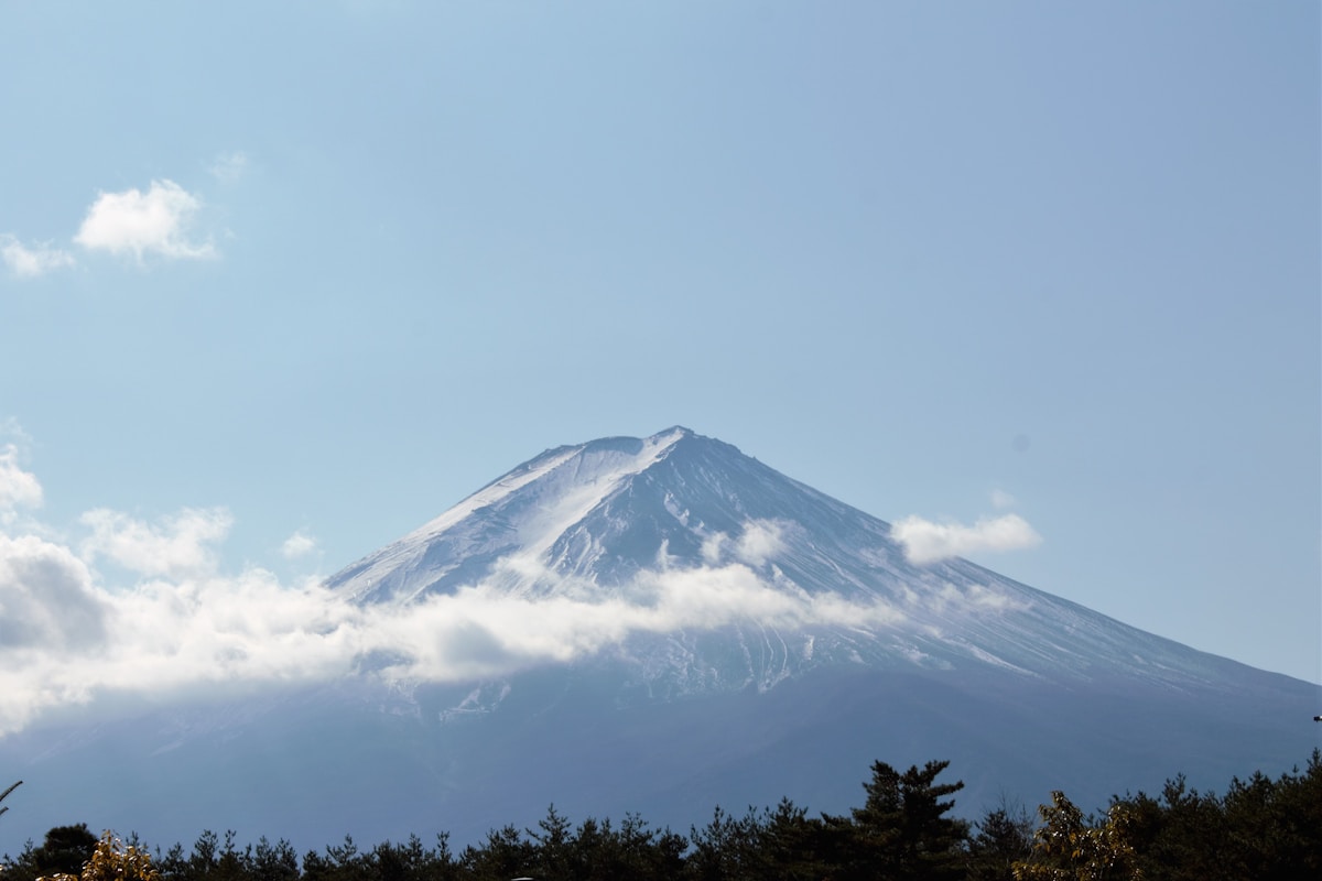
Costa Rica fits a remarkable amount of terrain into a country the size of West Virginia. Two coastlines with different swells. Active volcanoes above 3,000 metres. Cloud forests, jungles, and mangroves. All of it connected by roads that take you from Pacific waves to Caribbean heat in under 4 hours.
For athletes, this density is the point. You can surf at dawn, run a volcano trail at midday, and swim in a warm river by afternoon. The variety never gets stale. The climate never forces you inside. And the culture of "pura vida" means nobody is in a rush, which turns out to be exactly the pace that endurance athletes perform best at.
Where Should Surfers Go in Costa Rica?
The Pacific coast offers consistent waves from May through November on the south and year-round on the northwest. Guanacaste province in the north has warm water, offshore winds, and point breaks that peel forever.
Tamarindo is the accessible starting point: multiple breaks within walking distance, surf schools, board rentals, and a town built around the lineup. Playa Grande next door gets bigger and less crowded. Witch's Rock and Ollie's Point in Santa Rosa National Park require a boat trip but deliver empty, world-class waves.
Further south, Santa Teresa and Mal País have become the surf athlete's base. The break at Playa Hermosa (near Santa Teresa, not the one near Jacó) is heavy and hollow. The surrounding area has yoga studios, gyms, and a community of surfers who train like professionals.
On the Caribbean side, Puerto Viejo catches December through March swells with Salsa Brava, a fast, shallow reef break that attracts experienced surfers. The vibe is mellower, the water is warmer, and the crowds are smaller.
Water temperature hovers between 27 and 29 degrees Celsius year-round. No wetsuit needed. Ever.
What Are the Best Trail Running Routes?
Cerro Chirripó, Costa Rica's highest peak at 3,820 metres, is the trail running centrepiece. The route from San Gerardo de Rivas to the summit climbs 2,400 metres over 19 kilometres through cloud forest, páramo, and finally above the tree line to a rocky peak with views of both oceans on clear mornings.
Most hikers take two days. Trail runners push for a single-day summit. The record is under 3 hours. The altitude is genuine and the trail is technical in sections, with root-covered forest paths giving way to exposed rock above 3,400 metres.
Volcán Arenal and the surrounding national park offer shorter but dramatic trails through recent lava flows and tropical forest. The trails loop around the base of the volcano with views of the perfect cone above. Evening runs catch the golden light on the volcano's flanks.
Monteverde Cloud Forest has trails through one of the most biodiverse environments on earth. The terrain is hilly, the air is humid, and the canopy closes overhead. You run through hanging moss, past hummingbirds, and over suspension bridges. The experience is as much sensory as it is athletic.
For coastal running, the beaches of Guanacaste offer hard-packed sand at low tide. Long beach runs at sunrise with warm water for a cooldown swim afterward is a daily routine for the athletes who live here.
How Does Volcano Training Work?
Costa Rica has over 200 volcanic formations, several of them active. The altitude, terrain, and heat combine to create natural training stress without needing sophisticated protocols.
Irazú volcano near San José reaches 3,432 metres with a paved road to the top. Cyclists and runners use it for altitude intervals. The air is noticeably thinner, the temperature drops 10 to 15 degrees from the capital, and the volcanic landscape feels otherworldly.
Poás volcano has trails around its crater lake at 2,700 metres. The short approaches make it perfect for altitude acclimatisation without committing to a full day on Chirripó.
The heat at lower elevations adds another training variable. Running in 30-degree humidity at sea level then driving up to 10-degree altitude the same day is a natural form of environmental training that professional athletes pay for in specialised facilities.
Is Costa Rica Good for Cycling?
The Pan-American Highway through the central valley is the main cycling artery. It climbs over the Cerro de la Muerte pass at 3,451 metres, making it one of the highest paved roads in Central America. The climb from San José takes most cyclists 4 to 6 hours.
Around the central valley, volcanic roads climb steeply from 1,000 metres to over 3,000. Irazú, Poás, and Barva all have paved access roads used by cyclists for interval training. The gradients are steep (8 to 12 percent) but the distances are moderate (15 to 30 kilometres).
Mountain biking in Costa Rica is underrated. The trails around La Fortuna, Arenal, and Monteverde offer technical single track through jungle. River crossings, mud, and roots are standard. The tropical forest setting makes even moderate trails feel adventurous.
How Much Does It Cost?
Costa Rica is more expensive than other Central American countries but cheaper than European or North American equivalents for athletes.
A training month costs 1,200 to 2,500 USD depending on location and lifestyle. Surfing towns like Santa Teresa and Nosara are more expensive (tourist premium). Inland towns like San Ramón or San Isidro are significantly cheaper.
Accommodation ranges from 400 USD for a basic room to 1,200 for a furnished apartment in a surf town. Local meals (casados) cost 4 to 7 USD at sodas (local restaurants). Surf board rental is 15 to 25 USD per day.
The healthcare system is excellent and affordable. Travel insurance is recommended but emergency care is competent and much cheaper than the US.
When Should You Go?
December through April is dry season on the Pacific side. This is prime time for surf, cycling, and trail running with minimal rain and reliable sunshine.
May through November brings afternoon rains but mornings are often clear. Trail runners and surfers can train in the morning and rest through the afternoon showers. The landscape is dramatically greener and the tourist crowds thin out.
The Caribbean coast has opposite seasons: driest in September and October when the Pacific side is wettest.
For Chirripó, the summit is best from December through April when cloud cover is lowest and the trail is driest.
Getting Started
Fly into San José. Spend 2 to 3 days in the central highlands acclimatising and trail running on volcanic terrain. Then head to the Pacific coast for surf and coastal training.
Santa Teresa, Nosara, and Tamarindo all have established athlete communities. Gyms, yoga studios, and surf coaching are available everywhere. The infrastructure supports full-time training without sacrifice.
ZealZag members in Costa Rica share surf forecasts, trail conditions, and the local spots where athletes train between sessions. The pura vida approach to training, consistent effort without pressure, produces surprising results. Connect with locals who have found the rhythm.